首尔环城步道

People and Nature go Together

首尔环城步道 2.0

首尔环城步道2.0,21条彩色线路环绕首尔一周的手绘地图

本指南手册收录了首尔环城步道全21条线路各自的详细地图,同时提供有关周边步道旅游景点休息区的丰富信息。

简单 7 中等 10 困难 4 共 159.5 公里

全21条线路一图总览

首尔地形图上以颜色区分的全21条线路

沿途指引标识

在现场可依靠橙色丝带、指示牌与红色盖章亭辨认方向。每个盖章亭都标有위치번호(位置编号),紧急时拨打119并报出该编号,即可被迅速救援。

首尔环城步道指引系统:步道标识、编号标识、盖章站、丝带、箭头与地面标记

21条线路

Suraksan Mt. Course,线路地图
Suraksan Mt. Course,线路介绍与周边观光景点

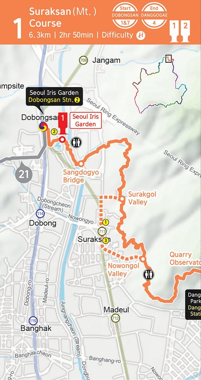
Suraksan Mt. Course 수락산 코스

6.3 km 2h 50min 困难
起点 Dobongsan Stn (Lines 1, 7) 도봉산역
终点 Danggogae Stn (Line 4) 당고개역

Begins at Dobongsan Station, climbs Suraksan Mountain to Danggogae Park Fork. Steep but the rocky scenery is rewarding.

线路与周边景点

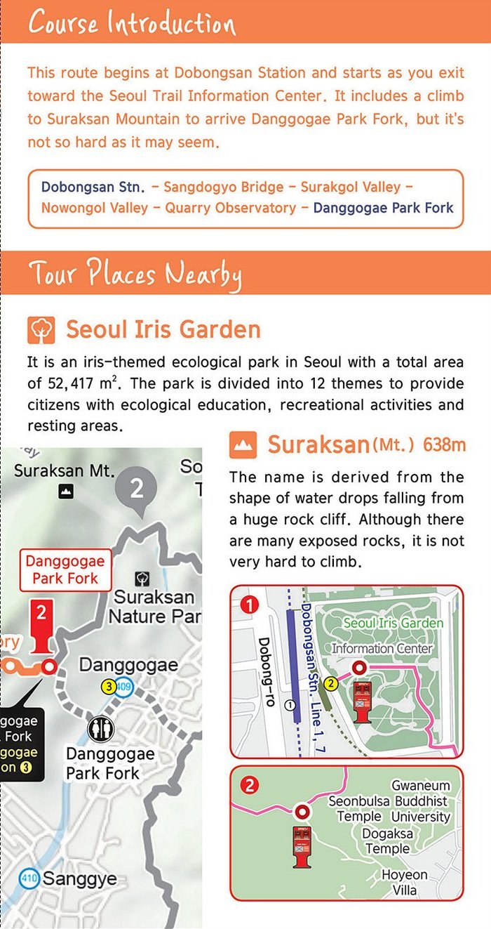
Dobongsan Stn → Sangdogyo Bridge → Surakgol Valley → Nowongol Valley → Quarry Observatory → Danggogae Park Fork

Seoul Iris Garden 서울창포원

An iris-themed ecological park spanning 52,417 m², divided into 12 themes for ecology, recreation, and rest.

Suraksan Mt. 수락산 638 m

Named for the shape of water drops falling from a huge cliff. Many exposed rocks but climbable.

Deongneunggogae Course,线路地图
Deongneunggogae Course,线路介绍与周边观光景点

Deongneunggogae Course 덕릉고개 코스

5.4 km 2h 50min 困难
起点 Danggogae Stn (Line 4) 당고개역
终点 Danggogae Stn (Line 4) 당고개역

A loop from Danggogae Park Fork through Deongneung-gogae Pass back to Sanggye-dong Royal Azalea Park. Two stamp stations.

线路与周边景点

Danggogae Park Fork → Hangnimsa Fork → Deongneung-gogae Pass → Sanggye-dong Royal Azalea Park

Hangnimsa Temple 학림사

A Jogye Order branch temple founded in 671 by the great Buddhist priest Wonhyo. Monk Hyegeun practiced here during the Goryeo Dynasty.

Suraksan Recreational Forest 수락산 자연휴양림

Korea's first urban recreational forest near Danggogae Stn (Line 4). Gentle slopes, scenic views. Opened 2024.

Buramsan Mt. Course,线路地图
Buramsan Mt. Course,线路介绍与周边观光景点

Buramsan Mt. Course 불암산 코스

6.9 km 2h 30min 中等
起点 Danggogae Stn (Line 4) 당고개역
终点 Hwarangdae Stn (Line 6) 화랑대역

Starts at Royal Azalea Park, climbs to Buramsan, then descends gradually through Hwarangdae Park to Hwarangdae Station.

线路与周边景点

Sanggye-dong Royal Azalea Park → Buramsan Observatory → Hakdoam Fork → Buramsan Mt → Gongneungsan → Baeksemun Gate → Hwarangdae Stn

Hakdoam Temple
Hakdoam Temple 학도암

In 1624 (2nd year of King Injo, Joseon), the temple was relocated. Famous for a 22.7 m rock-carved seated Avalokitesvara built in 1872.

Buramsan Mt. 불암산 508 m

Named after the large rock on the mountain top that resembles a Buddha (Bul-am = Buddha rock).

Mangusan Mt. & Yongmasan Mt. Course,线路地图
Mangusan Mt. & Yongmasan Mt. Course,线路介绍与周边观光景点

Mangusan Mt. & Yongmasan Mt. Course 망우산·용마산 코스

7.7 km 3h 中等
起点 Hwarangdae Stn (Line 6) 화랑대역
终点 Sagajeong Stn (Line 7) 사가정역

A flat route across Mukdongcheon Stream to Joongnang Campground, then climbing to Mangu Cemetery Park via Kkalttakgogae Pass.

线路与周边景点

Hwarangdae Stn → Bonghwasan → Sinnae Eoul Park → Joongnang Campground → Mangu Cemetery Park → Kkalttakgogae Pass Rest Area

Mangusan Mt. 망우산 281.7 m

Spans Mangu-dong and Myeonmok-dong. Burial place of 9 notable figures including writers, scholars, and artists.

Mangu Cemetery Park 망우공원

A history-themed park featuring graves of Han Yong-un, Bang Jeong-hwan (founder of Children's Day), and painter Lee Jung-seob.

Joongnang Campground 중랑캠핑숲

A family-themed campground with picnic areas. Healthy forest, ecological education park for youth and small outdoor activities.

Achasan Mt. Course,线路地图
Achasan Mt. Course,线路介绍与周边观光景点

Achasan Mt. Course 아차산 코스

4.6 km 2h 10min 中等
起点 Sagajeong Stn (Line 7) 사가정역
终点 Gwangnaru Stn (Line 5) 광나루역

Stone steps lead up to Achasan Mountain. Encounter Three Kingdoms-era forts and arrive at Gwangnaru Station.

线路与周边景点

Kkalttakgogae Pass Rest Area → Fork → Achasan Mt → Sunrise Square → Information Center → Gwangnaru Stn

Achasan Mt. 아차산 295.7 m

In the past, Achasan was called Namhaengsan. It bulged towards the south. Locals also call it Akkisan, Aksan, Ekkesan, or Eksan.

Achasan Fort
Achasan Fort 아차산성

Considering excavated relics, the forts on Achasan appear to be remains from the Three Kingdoms period. Likely a Goguryeo fortification.

Godeoksan Mt. Course,线路地图
Godeoksan Mt. Course,线路介绍与周边观光景点

Godeoksan Mt. Course 고덕산 코스

9.3 km 3h 简单
起点 Gwangnaru Stn (Line 5) 광나루역
终点 Godeok Stn (Line 5) 고덕역

Crosses the Hangang River via Gwangjingyo Bridge and follows Gwangnaru Hangang Park. After Godeoksan, you encounter Amsa-Prehistoric Settlement Site.

线路与周边景点

Gwangnaru Stn → Hanyang Hangang Park → Northern End of Gwangnaru → Amsa Interchange → Archaeological Site → Godeok Stn

Godeoksan Mt. 고덕산 86.3 m

Lee Yang-jung, a loyal supporter of the Goryeo Dynasty, retreated here after the fall of Goryeo. The mountain bears his memory.

Amsa-Prehistoric Settlement Site
Amsa-Prehistoric Settlement Site 암사선사유적지

Neolithic ruins of pit houses dating to 4000–3000 BC. Excavated and restored 1981–1988, then opened as a settlement-site park.

Iljasan Mt. Course,线路地图
Iljasan Mt. Course,线路介绍与周边观光景点

Iljasan Mt. Course 일자산 코스

7.7 km 3h 15min 简单
起点 Godeok Stn (Line 5) 고덕역
终点 Ogeumgyo Br. 1 오금교 1

Starts at Myeongil Neighborhood Park and follows the ridge of Iljasan Mountain. Passes through Bangi-dong Ecosystem Landscape Conservation Area.

线路与周边景点

Godeok Stn → Flower Market → Sunrise Park → Accessway to Iljasan → Bangi-dong Eco Conservation Area → Ogeumgyo Br. 1

Iljasan Mt. 일자산 134 m

On the eastern outskirts of Seoul. From Baedari in Gambok-dong to Choi-dong, it stretches roughly 5 km north–south. Designated as an Urban Nature Park in 1971.

Iljasan Dungui (Duncho's Cave) 일자산 둔굴

In the late Goryeo period, the scholar Yi Jip fled to a cave at Iljasan, where he lived under the nickname "Duncho" to commemorate his hardships.

Jangjicheon & Tancheon Course,线路地图
Jangjicheon & Tancheon Course,线路介绍与周边观光景点

Jangjicheon & Tancheon Course 장지천·탄천 코스

8.6 km 2h 35min 简单
起点 Ogeumgyo Br. 1 오금교 1
终点 Suseo Stn (Line 3) 수서역

A flat route along three streams. Seongnaecheon, Jangjicheon, and Tancheon. Passing Songpa-gu and Gangnam wetlands.

线路与周边景点

Ogeumgyo Bridge 1 → Seongnae Stream → Wireseong Bridge → Seongnaegyo Bridges → Jangji Bridge → Tancheon Stream → Suseo Stn

Bangi-dong Eco Conservation Area 방이동 생태경관보전지역

A protected ecological area in Songpa-gu along Wireseong-daero, preserving urban wetland habitat for waterfowl and rare plants.

Daemosan Mt. & Guryongsan Mt. Course,线路地图
Daemosan Mt. & Guryongsan Mt. Course,线路介绍与周边观光景点

Daemosan Mt. & Guryongsan Mt. Course 대모산·구룡산 코스

10.7 km 4h 50min 困难
起点 Suseo Stn (Line 3, SRT) 수서역
终点 Maeheon Citizen's Forest 매헌시민의숲

Follows the ridges of Daemosan and Guryongsan Mountains. Pleasant walk through dense forest. The longest course in the trail network.

线路与周边景点

Suseo Stn → Bulgukasa Temple → Seoul Trail Info Center → Maeheon Citizen's Forest

Daemosan Mt. 대모산 293 m

Located south of Gaepo-dong and Irwon-dong of Gangnam-gu. Near Heolleung. The royal tombs of King Taejong and Empress Wongyeong.

Guryongsan Mt.
Guryongsan Mt. 구룡산 306 m

Mountain of nine dragons. Legend says a pregnant woman screamed at the sight of 10 dragons ascending to heaven, causing one to fall. Only 9 reached the heavens.

Umyeonsan Mt. Course,线路地图
Umyeonsan Mt. Course,线路介绍与周边观光景点

Umyeonsan Mt. Course 우면산 코스

10.6 km 3h 20min 中等
起点 Maeheon Citizen's Forest 매헌시민의숲
终点 Sadang Stn (Lines 2, 4) 사당역

Circles the Umyeonsan slopes, reaching Daeseongsa Temple at Sadang Station Fork. Easygoing forest walk with cultural stops.

线路与周边景点

Seoul Trail Info Center (Maeheon Citizen's Forest) → Daeseongsa Temple → Sadang Stn Fork

Umyeonsan Mt. 우면산 293 m

Named because the mountain resembles a sleeping cow ("U-myeon" = cow-face). Also called Gwanamsan. Said to look like a huge rock wearing a crown.

Daeseongsa Temple 대성사

Said to have been founded in 384 AD by Maranata, a monk from India. The great Buddhist priest Boyu stayed here in the Joseon Dynasty.

Seoul Arts Center 예술의전당

A festival theater, concert hall, art gallery, museum, and learning center accommodating a wide range of arts activities.

Gwanaksan Mt. Course,线路地图
Gwanaksan Mt. Course,线路介绍与周边观光景点

Gwanaksan Mt. Course 관악산 코스

5.7 km 2h 30min 中等
起点 Sadang Stn (Lines 2, 4) 사당역
终点 Gwanaksan Park (Shillim Line) 관악산공원

Passes Gwaneumsa Temple on the slopes of Gwanaksan Mountain. Continues through Nakseongdae Park, reaching the entrance of Gwanaksan.

线路与周边景点

Sadang Stn Fork → Gwaneumsa Temple → Nakseongdae Park → Gwanaksan Park Entrance

Gwanaksan Mt. 관악산 632.2 m

The summit is composed of rocks. Named because it looks like it is wearing a "gat". A Korean traditional hat. Large rocks and huge peaks form a magnificent view.

Nakseongdae Park 낙성대공원

The holy place where Gang Gam-chan, a Goryeo Dynasty general, was born. Named after a legend that a star fell the day he was born.

Hoamsan Mt. Course,线路地图
Hoamsan Mt. Course,线路介绍与周边观光景点

Hoamsan Mt. Course 호암산 코스

7.3 km 3h 30min 中等
起点 Gwanaksan Park (Shillim Line) 관악산공원
终点 Seoksu Stn (Line 1) 석수역

Passes through significant sites such as the Catholic Samseongsan Sanctuary and Hoapsa Temple on Hoamsan Mountain to reach Seoksu Station.

线路与周边景点

Gwanaksan Park → Hoapsa Temple → Seoksu Stn

Catholic Samseongsan Shrine 가톨릭 삼성산 성지

The ruins of a church where three Catholic priests are buried. Martyred during the Gihae Persecution in 1839. Coincidentally, the name Samseongsan also originates from three Buddhist priests who lived here as ascetics in the late Goryeo Dynasty.

Anyangcheon Upstream Course,线路地图
Anyangcheon Upstream Course,线路介绍与周边观光景点

Anyangcheon Upstream Course 안양천 상류 코스

8 km 2h 05min 简单
起点 Seoksu Stn (Line 1) 석수역
终点 Guil Stn (Line 1) 구일역

Open until evening hours. Follows Anyangcheon Stream with several subway stations conveniently located along the way.

线路与周边景点

Seoksu Stn → Geumcheongyo Br → Cheolsango Br → Gwangmyeonggyo Br → Guil Stn

Anyangcheon Stream 안양천

34.8 km long. Originates at Anyangsa Temple in Samseongsan Mountain. The section from Anyang-si to where it meets the Hangang River is designated as a national stream.

Anyangcheon Downstream Course,线路地图
Anyangcheon Downstream Course,线路介绍与周边观光景点

Anyangcheon Downstream Course 안양천 하류 코스

10.2 km 2h 25min 简单
起点 Guil Stn (Line 1) 구일역
终点 Gayangdaegyo Br. Southern End 가양대교 남단

A continuation of the Anyangcheon route. From Guil Station along the Hangang River to Gayang Bridge. Fully accessible.

线路与周边景点

Guil Stn → Ogeumgyo Br → Sinjeonggyo Br → Mokdonggyo Br → Yeomchanggyo Br → Gayangdaegyo Br. Southern End

Seoul Botanic Park
Seoul Botanic Park 서울식물원

Divided into four areas. Forest Field, Lake Garden, Wetland, and Botanic Garden. Tropical and Mediterranean species in a large dome greenhouse. Free entrance to most zones.

Noeul-Haneul Park Course,线路地图
Noeul-Haneul Park Course,线路介绍与周边观光景点

Noeul-Haneul Park Course 노을·하늘공원 코스

7.7 km 2h 10min 简单
起点 Gayangdaegyo Br. Southern End 가양대교 남단
终点 Jeungsan Stn (Line 6) 증산역

Crosses the Hangang River via the bridge's walkway, then passes through Noeul Park, Haneul Park, and the World Cup Stadium concluding at Jeungsan Stn.

线路与周边景点

Gayangdaegyo Br Southern End → Northern End → World Cup-daegyo Br → Bulgwangcheon Stream → Jeungsan Stn Fork

World Cup Stadium
World Cup Stadium 월드컵경기장

Located in Nanjido-gil, Mapo-gu. Built for the 2002 FIFA World Cup. Capacity of 66,806 people.

World Cup Park 월드컵공원

Five areas: Pyeonghwa Park, Haneul Park, Noeul Park, Nanjicheon Park, and Nanji Hangang Park. Created to commemorate the first World Cup of the 21st century.

Bongsan-Aengbongsan Mt. Course,线路地图
Bongsan-Aengbongsan Mt. Course,线路介绍与周边观光景点

Bongsan-Aengbongsan Mt. Course 봉산·앵봉산 코스

9.1 km 4h 15min 困难
起点 Jeungsan Stn (Line 6) 증산역
终点 Gupabal Stn (Line 3) 구파발역

Starts at the fork near Jeungsan Station. Follows the ridges of Bongsan and Aengbongsan Mountains. Overlaps with Eunpyeong Trail.

线路与周边景点

Jeungsan Stn Fork → Bongsan Sports Park → Bongsan Observatory → Bongsan Mt → Aengbongsan Mt → Gupabal Stn

Bongsan Mt. / Aengbongsan 봉산 / 앵봉산 235.1 m

Bongsan (209m) sits on the border of Gusan-dong, Eunpyeong-gu and Goyang-si. Named for the beacon on the summit. Around 100 tree species including hornbeams flourish here.

Bongsan Ecological Conservation Area 봉산 생태경관보전지역

A 73,478 m² conservation area home to a rare large colony of Sorbus trees. Making this area conservation-significant.

Bukhansan Mt. & Eunpyeong-gu Course,线路地图
Bukhansan Mt. & Eunpyeong-gu Course,线路介绍与周边观光景点

Bukhansan Mt. & Eunpyeong-gu Course 북한산·은평구 코스

5.9 km 2h 45min 中等
起点 Gupabal Stn (Line 3) 구파발역
终点 Bukhansan Eco Park (Bulgwang Stn) 북한산생태공원 / 불광역

Passes through Seollima Temple via Gureunjong-gil. Overlaps with Bukhansan Dulle-gil sections 1 and 2. Easy access from the subway.

线路与周边景点

Gupabal Stn → Seollima Temple → Bukhansan Dulle-gil sec 1-2 → Bukhansan Eco Park

Bukhansan Mt. 북한산 835.6 m

Along with Baekdusan, Jirisan, Geumgangsan, and Myohyangsan, Bukhansan is one of the five great mountains of Korea. Includes the granite peaks Insubong and Mangyeongdae. 14 fortress gates including Daeseomun and Bogungmun still retain their original shape.

Multiculture Museum 다문화박물관

Promotes understanding of cultures from Europe, North America, the Middle East, and Southeast Asia. Hands-on programs for crafts, cooking, food tasting, and traditional dance.

Bukhansan Mt. Jongno Course,线路地图
Bukhansan Mt. Jongno Course,线路介绍与周边观光景点

Bukhansan Mt. Jongno Course 북한산·종로 코스

7.4 km 4h 中等
起点 Bulgwang Stn (Lines 3, 6) 불광역
终点 Hyeongjebong Peak Entrance 형제봉 입구

Extends from Bukhansan Eco Park to the entrance of Hyeongjebong Peak. Overlaps with sections 4–6 of Bukhansan Dulle-gil. Pyeongchanggyeongnae-gil section.

线路与周边景点

Bukhansan Eco Park → Jeonsinsa Temple → Hyeongjebong Peak Entrance

Samseong Museum of Publishing 삼성출판박물관

In Pyeongchang-dong cluster of museums. Showcases Korean publishing history.

Kimdaljin Archives Museum 김달진미술자료박물관

Houses art archives and reference materials in Pyeongchang-dong's museum district.

Seoul Museum of Art Archives 서울시립미술아카이브

Part of the Seoul Museum of Art network. Archives of contemporary Korean art.

Bukhansan Mt. Seongbuk-gu Course,线路地图
Bukhansan Mt. Seongbuk-gu Course,线路介绍与周边观光景点

Bukhansan Mt. Seongbuk-gu Course 북한산·성북구 코스

6 km 2h 50min 中等
起点 Hyeongjebong Peak Entrance 형제봉 입구
终点 Hwagye Temple Entrance 화계사 입구

From Hyeongjebong Peak entrance to Hwagyesa Temple. Overlaps sections 5 (Myeongsang-gil), 6 (Pyeongchang-gil), and 7 (Solsaem-gil) of Bukhansan Dulle-gil.

线路与周边景点

Hyeongjebong Peak Entrance → Bukhansan Dulle-gil → Hwagye Temple Entrance

Bukhansan Dulle-gil 북한산 둘레길

Connects the ridges of Bukhansan and Dobongsan along a gentle path at the foot of the mountains. Passes through Jongno-gu, Eunpyeong-gu, Seongbuk-gu, Dobong-gu, Gangbuk-gu, and Yangju-si. The trail has 21 sections.

Hwagyesa Temple 화계사

A Joseon-era temple, now offering Templestay programs. Reachable from Suyu Stn (Line 4).

Gyeongguksa Temple 경국사

Templestay-certified temple in Jeongneung. A quiet retreat below Bukhansan ridges.

Bukhansan Mt. Gangbuk-gu Course,线路地图
Bukhansan Mt. Gangbuk-gu Course,线路介绍与周边观光景点

Bukhansan Mt. Gangbuk-gu Course 북한산·강북구 코스

7.1 km 3h 30min 中等
起点 Hwagye Temple Entrance 화계사 입구
终点 Bukhansan Ui Stn 북한산우이역

Runs from Hwagyesa Temple to Bukhansan Ui Station. Overlaps with sections 7–9 of the Bukhansan Dulle-gil. Includes the April 19th National Cemetery.

线路与周边景点

Hwagyesa Temple → Yeongbongsa Temple → Solbat Park → April 19 Minjumyo → Seoul Gangbuk Youth Center → Jangmiwon Market → Bukhansan Ui Stn

April 19th National Cemetery
April 19th National Cemetery 4·19 민주묘지

Seven columns of the central tower represent the spirit of the April Revolution. 20 funeral codes and guardian statues surround the site. Commemorating the 1960 student uprising that toppled the Rhee regime.

Hwagyesa Temple 화계사

Templestay-certified temple. Overlap with the previous course's ending tour place.

Bukhansan Mt. & Dobong-gu Course,线路地图
Bukhansan Mt. & Dobong-gu Course,线路介绍与周边观光景点

Bukhansan Mt. & Dobong-gu Course 북한산·도봉구 코스

7.3 km 3h 25min 简单
起点 Bukhansan Ui Stn 북한산우이역
终点 Dobongsan Stn (Lines 1, 7) 도봉산역

Closes the loop. Overlaps with sections of Bukhansan Dulle-gil and brings the trail back to Dobongsan Stn (Course 1's start).

线路与周边景点

Bukhansan Ui Stn → Royal Cemetery-gil Starting Point → Musugol Village → Dobongsan Info Center → Dobongsan Stn

Dobongsan Mt. 도봉산 740.2 m

On the border of Dobong-gu and the northern parts of Seoul / Uijeongbu-si. Highest peak Jaunbong (740.2 m). Along with Bukhansan, Dobongsan is part of the Bukhansan Mountain network bordered by Uiryeong Pass.

Cheonchuksa Temple
Cheonchuksa Temple 천축사

Templestay-certified temple at the foot of Dobongsan Mountain, founded in the Goryeo era.

实用提示

最佳时节

4月至6月与9月至11月初最为理想。夏季炎热潮湿,冬季步道结冰。出发前请查看119气象警报。

离线地图

Naver地图与Kakao地图都收录了全部21条线路。在山脊上失去信号前,先把起点站标记好。

盖章手册

在任一首尔环城步道游客中心(水落山、梅轩、峨嵯山、冠岳山)免费领取。在每个盖章亭盖章即可获得完走证书。

从最简单的开始

不妨试试第13条线路(安养川上游)或第8条线路(炭川)。平坦的溪畔步道,最适合时差未消的第一天。

最难的线路

第1条线路(水落山)、第9条线路(大母山·九龙山)、第16条线路(峰山·鹰峰山)。岩石攀登路段,需要正规登山鞋。

紧急情况

拨打119。每个盖章亭都标有위치번호(位置编号)。向接线员报出该编号即可被迅速救援。

游客中心

线路说明、路线、手册地图与指引标识图片均来自首尔特别市《首尔环城步道2.0官方指南手册》(gil.seoul.go.kr)。依据KOGL第1类型(공공누리 제1유형,注明出处)再发布。补充风景照片来自Wikimedia Commons(CC BY-SA / 公有领域)。

这个页面对你有帮助吗? 告诉我们哪里可以改进,每条都会认真看。